
Drought Stress in the Summer 2026
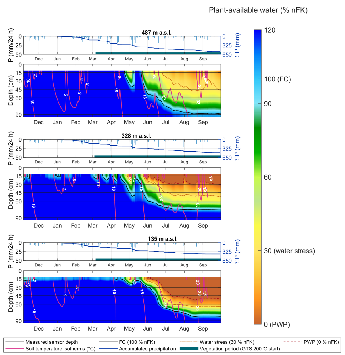
The drought in the summer of 2026 is clearly evident in our measurement data. Since May, the water supply available to plants has been declining sharply. At some locations, the drying extends to a depth of 60 cm. This is based on continuous soil moisture measurements, field surveys, and laboratory analyses. From these, we calculate the level of usable field capacity (nFK). Values below 30% indicate a severely limited water supply to vegetation and increasing drought stress.
This can particularly affect moisture-dependent species and biotopes. It is also relevant for water suppliers, as changes in the soil water balance influence important ecosystem services in water protection areas, such as groundwater recharge as well as filtration and buffering functions.
BioWaWi-AI
Protecting Biodiversity and Water Supplies with AI
Intact ecosystems are a vital foundation for a secure drinking water supply. Forests, meadows, wetlands, and soils not only provide habitats for numerous animal and plant species but also perform important functions in the water cycle. They influence groundwater recharge, store and filter water, and thus help safeguard our water resources. However, climate change and shifts in land use are placing these ecosystems under increasing pressure. Prolonged dry spells, in particular, can alter the water cycle and endanger sensitive species and habitats.
This is where the BioWaWi-KI research project comes in. It investigates how artificial intelligence (AI) can help us better understand the complex relationships between the water cycle, biodiversity, and ecosystem services, and detect critical changes at an early stage. The target is to translate scientific findings into concrete decision-making frameworks for the protection and sustainability of water protection areas.
The study area consists of the water protection areas managed by Stadtwerke Bühl, located at the transition between the Upper Rhine Plain and the Black Forest. The diverse landscape, featuring forests, agricultural land, water bodies, and wetland habitats, provides a habitat for numerous species, some of which are endangered. At the same time, these areas are of great importance for the regional drinking water supply.
BioWaWi-KI builds on the predecessor project BioWaWi and expands its extensive research through continuous environmental monitoring and the use of modern AI methods. Weather and soil moisture measurements, groundwater and surface water data, pedological studies, and information on vegetation, biotopes, and animal species are linked with satellite imagery, automated camera systems, and hydrological models. This creates a comprehensive dataset for analyzing changes in the landscape both spatially and temporally.
A particular focus is on the early detection of drought stress. AI will be used to identify patterns and correlations in the various environmental data sets that may indicate critical developments for moisture-dependent species and biotopes. Building on this, forecasts and scenarios will be developed to assess, for example, the consequences of prolonged droughts or potential protective measures.
The results will ultimately be integrated into an AI-supported early warning and decision-making system that assists water utilities in managing their protected areas. In collaboration with Stadtwerke Bühl and other regional stakeholders, the project is investigating how suitable measures for preserving biodiversity and important ecosystem services can be derived from this data. The methods developed are intended to be transferable to other water protection areas and regions in the future.
In this way, BioWaWi-KI combines biodiversity research, water management, and artificial intelligence with a common target: to understand changes in our ecosystems at an early stage, preserve their natural functions, and secure the water supply in the long term.